Restrictions
There are following general restrictions:
§ The
triangulation points and constraints must be projectable: a 2d CDT can
intrinsically not triangulate points with identical xy-coordinates or recessing
caves. Therefore, triangulation points with identical xy-coordinates will be
removed during the triangulation process. The point with the highest
z-coordinate is kept.  General rule: the CDT can only “see” the
xy-projection of the triangulation points and constraints in UCS. It has no
height information during the triangulation
process.
Use the CC:POINTS:ELIM2D command to eliminate points with
identical xy-coordinates before triangulating. This keeps your input data
clean.
General rule: the CDT can only “see” the
xy-projection of the triangulation points and constraints in UCS. It has no
height information during the triangulation
process.
Use the CC:POINTS:ELIM2D command to eliminate points with
identical xy-coordinates before triangulating. This keeps your input data
clean.
§ Constraints
must not overlap and must not be self-intersecting. Constraints may have
identical start or end points and may be collinear. However, they must not
overlap, be self-intersecting or coincident: since the CDT operates in the UCS xy-plane only,
degenerate constraints define over-determined points along their intersection
(i.e. possibly different z-heights at the same xy-coordinate).
Use the AutoCAD command _overkill to eliminate
overlapping or coincident lines.
§ Boundaries
must be closed and linear. The CDT only accepts closed linear polyline objects as
boundaries. The polylines must exclusively consist of line
segments.
Use the AutoCAD command _decurve to linearize a
polyline if it does not exclusively consist of line segments.
§ Boundaries must lie inside the convex hull of triangulation points and constraints. Boundaries allow defining arbitrary shaped convex and concave shaped holes, islands and bounds in the triangulated surface. This implies that boundaries can only be defined where a triangulated surface exists, precisely being the area inside the convex hull of triangulation points and constraints.
§ A Delaunay
triangulation is not unique over an evenly spaced rectangular raster. As a
consequence, the direction of the diagonal in a raster may alter when
triangulating identical point data twice depending on the insertion order of the
triangulation points.
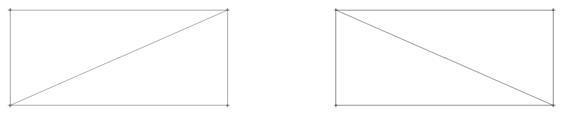
Figure 36: Two
valid Delaunay triangulations over a rectangular raster